Observed & Projected Climate Change in Southwestern Colorado
Understanding how climate has changed, how it is likely to change in the future, and what this means for water, wildfire, ecosystems, species, and people requires complex interdisciplinary study. It also requires an understanding of uncertainty, as projections of the future, even if they are based on the best data and expert modeling available, should not be treated as "for certain" forecasts. Instead, scientists and policy makers rely on a suite of global circulation (GCM) models, each with its strengths and weaknesses, to develop plausible scenerios for our future.
Understanding climate change in the San Juan Mountain region has some special considerations. First, the mountains and valleys that make up our region are what scientists refer to as "complex topography" that is difficult to model on small geographic scales. Because of this complex terrain, more observing stations are needed to represent small scale patterns in climate. Second, in many cases, studies of climate effects (on ecosystems, species, etc.) for our region do not exist. Until they can be completed, our best knowledge comes from studies of similar regions.
The following is a compilation of the results of pertinant studies providing a brief summary for climate change observations and projections in Southwest Colorado. Understanding the existing and anticipated changes in climate is the first step in preparing for the impacts associated with changes.
Temperature, Evaporation/Evapotranspiration, Precipitation, Snowpack, and Streamflow
The climate summary, compiled by MSI, is being used by the Four Corners Office of Resource Efficency (4CORE) - for La Plata County, Colorado. The table at the end of this section summarizes the projected climate changes in Southwest Colorado and includes details on the source of these projections and level of certainty. The table demonstrates that changes in several factors are interrelated and that the impacts of these changes will be complex.
Temperature

- Southwestern Colorado has warmed about 2° F in the last three decades (i.e., 1977 to 2007). This rate of warming is the same as for Western Colorado, but greater than the Western US, or any other region of the US except Alaska.
- Temperatures are likely to increase by an additional 1.5 to 3.5 °F by 2025 and 2.5 to 5.5 °F by 2050.
- Summers are projected to warm more than winters. By 2050, typical average monthly temperatures in the summer are projected to be as warm as or warmer than the hottest 10% of summers from 1950 to 1999.
- The climate of the mountains is projected to migrate upward in elevation and the climate of the Desert Southwest to progress up into the valleys.
- Examples of Potential Impacts:
- Changes in agricultural crop production and spread of agricultural pests.
- Earlier snowmelt and timing of peak river flows.
- Increased energy usage for heating and cooling.
- Increased heat-related illnesses and spread of disease.
- More amenity-led migration to the mountains from desert communities.
Evaporation and Evapotranspiration
- Due to increased temperatures, the rate at which water is evaporated from water bodies, soil, and vegetation is very likely to increase.
- This will make the environment drier even if precipitation stays the same.
- Examples of Potential Impacts
- Decrease in streamflow and water stored in reservoirs, especially in hot, dry years.
- Decreased soil moisture for crops and natural vegetation.
- Increased irrigation needs or shifts to more drought-resistant crops.
- Shifts in elevation ranges of plants and animals.
- Increased wildfire occurrence and forest die-offs.
Precipitation

- The San Juan Mountain region is difficult to model for precipitation due to complex topography and natural variability in precipitation patterns.
- Projections of change in amounts of precipitation for the region are not in consensus. Some studies indicate that annual precipitation will decrease slightly while others project an increase in the winter.
- Some models project more variable precipitation patterns with more frequent extreme events.
- Examples of Potential Impacts:
- Increased storm events and severity.
- Change in aquatic habitat.
Snowpack and Streamflow
- Warming temperatures are projected to have significant effects on snowpack, timing of snowmelt, and streamflow even without a decrease in precipitation.
- It is likely that in the future more precipitation will fall as snow, snowpacks will decrease and melt earlier, and peak streamflow will occur earlier in the spring.
- From 1978 to 2004, snowmelt already shifted about two weeks earlier in Western Colorado. Snowmelt has shifted even earlier in the Pacific Northwest and Northern California, however.
- Decreases in the amount of water contained in snowpacks are projected to be greater at elevations below 8,200 feet (i.e., a 20 to 60% reduction of snowpack by the period 2040 to 2069). Above 8,200 feet, the snowpack is anticipated to decrease by 10 to 20%.
- Examples of Potential Impacts
- More flooding in the spring.
- Reduced water availability in the summer.
- Shorter seasons for ski/snow and white water recreation industries.
- Increased summer recreation and tourism opportunities.
Literature Cited
Backlund, P., et al. 2008. The effects of climate change on agriculture, land resources, water resources, and biodiversity: Introduction. A Report by the U.S. Climate Change Science Program and the Subcommittee on Global Change Research. Washington, DC., USA, pp. 362. http://www.sap43.ucar.edu/documents/SAP_4.3_6.18.pdf
Barnett, T.P.; Pierce, D.W.; Hidalgo, H.G.; Bonfils, C.; Santer, B.D.; Das, T.; Bala, G.; Wood, A.W.; Nozawa, T.; Mirin, A.A.; Cayan, D.R.; Dettinger, M.D. 2008. Human-Induced Changes in the Hydrology of the Western United States. Science. 19: 1080-1083.
Christensen, N and D.P. Lettenmaier. 2006. A multimodel ensemble approach to assessment of climate change impacts to the hydrology and water resources of the Colorado River Basin. Hydrology and Earth Systems Science Discussion, 3, 1-44.
Clow, D. 2008. Changes in the Timing of Snowmelt in Colorado, Presentation at the 50th Annual Convention of the Colorado Water Congress, January 23-25, Denver, CO.
Hamlet, A.F.; Mote, P.W.; Clark, M.P.; Lettenmaier, D.P. 2007. 20th century trends in runoff, evapotranspiration, and soil moisture in the Western U.S. Journal of Climate. 20: 1468-1486.
IPCC 2007: Climate Change 2007 Synthesis Report: Contribution of Working Groups I, II and III to the Fourth Assessment Report of the Intergovernmental Panel on Climate Change, Core Writing Team, Pachauri, R.K. and Reisinger, A. (Eds.), pp 104. http://www.ipcc.ch/ipccreports/ar4-syr.htm
IPCC 2007: Climate Change 2007: The Physical Science Basis. Contribution of Working Group I to the Fourth Assessment Report of the Intergovernmental Panel on Climate Change. http://www.ipcc.ch/ipccreports/ar4-wg1.htm
IPCC 2008: IPCC Technical Paper VI, Climate and Water, Bates, B.C., Z.W. Kundzewicz, S. Wu and J.P. Palutikof (Eds.), 210 pp. http://www.ipcc.ch/ipccreports/technical-papers.htm
Miles, E.L.; Lettenmaier, D.P.; Mantua, N.J. [et al.]. 2007. HB1303 interim report: a comprehensive assessment of the impacts of climate change on the State of Washington. Seattle, WA: Climate Impacts Group, University of Washington.
Milly, PC, Dunne, KA, and Vecchia, AV. 2005. Global patterns of treds in streamflow ad water availability in a changing climte. Nature, 438, 347-350.
Mote, P.W.; Hamlet, A.F.; Clark, M.; Lettenmaier, D.P. 2005. Declining mountain snowpack in western North America. Bulletin of the American Meteorological Society. 86: 39-49.
National Academies of Science. 2007. Evaluating Progress of the U.S. Climate Change Science Program: Methods and Preliminary Results. Committee on Strategic Advice on the U.S. Climate Change Science Program, National Research Council. Pp. 178.
Salathé, E.P. 2006. Influences of a shift in North Pacific storm tracks on western North American precipitation under global warming. Geophysical Research Letters. 33: L19820.
Stewart, I.T.; Cayan, D.R.; Dettinger, M.D. 2005. Changes toward earlier streamflow timing across western North America. Journal of Climatology. 18: 1136–1155.
Timmermann, A.; Oberhuber, J.; Bacher, A.; Esch, M.; Latif, M.; Roeckner, E. 1999. Increased El Niño frequency in a climate model forced by future greenhouse warming. Nature. 398: 694-697.
Ranwala, I. 2008. Chapter 5 of Dissertation: 20th Century Climate Change In The San Juan Mountains In Southwest Colorado: Investigating long term trends in climate and hydrological variables and explaining the causes for a rapid climate change in the region between 1985-2005. Rutgers University. 35 pp.
Ray, A.J, Barsugli, J.J., Averyt, K.B., and 5 Others. 2008. Climate change in Colorado: A synthesis to support water resources management and adaptation. A report by the Western Water assessment for the Colorado Water Conservation Board. Pp. 53. http://cwcb.state.co.us/Home/ClimateChange/ClimateChangeInColoradoReport/
GLORIA Program
A Monitoring Program to Determine the Effect of Global Change on Alpine Plant Communities in the San Juan Mountains, SW Colorado
The Third Site in of the Global Observation Research Initiative in Alpine Environments (GLORIA) Program in North America
What is GLORIA and Why in the San Juan Mountains?
GLORIA is a long-term, global observation network for the comparative study of climate change impacts on mountain biodiversity, specifically plants. There are 42 GLORIA target regions worldwide, and nine are located in North America. GLORIA uses a multi-summit approach and standardized low-impact monitoring methodology, allowing the study of alpine plant communities and climate change impacts both within and among regions.

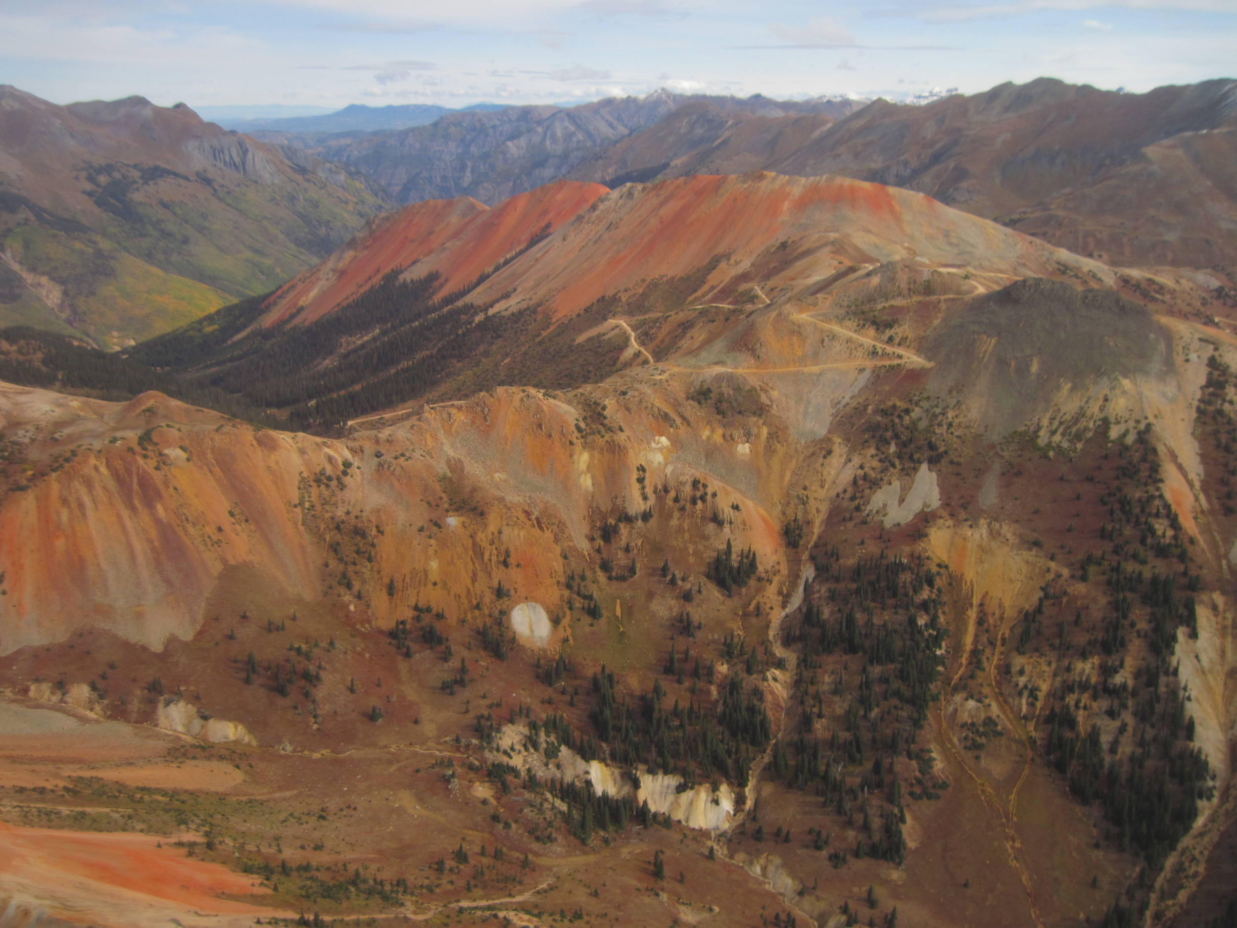
Ecosystems of the alpine life zone are considered to be particularly sensitive to global warming because they are adapted to low temperature conditions. Alpine communities are also limited in their migration ability to reach higher altitudes or latitudes due to the island nature of mountain tops. Alpine environments contain a relatively high number of endemic species (i.e., species that occur only locally) that risk extinction. A site in the San Juan Mountains is extremely useful in understanding alpine flora biodiversity, community patterns, and impacts of climate change, increasing air pollution, and spread of exotic plant species at a mid-latitude continental mountain range. In some areas of the San Juan Mountains, such as Silverton, temperatures have risen over one degree Celsius in the summer and four degrees Celsius in the winter since about 1970. It is crucial to understand how these increasing temperatures affect alpine tundra and treeline vegetation in this region.
What are the Benefits of the San Juan Mountain GLORIA Program?
Establishment of a long-term observation system that can detect early warning signs of climate change and other stresses such as air pollution and exotic species invasions.
Data on alpine plant communities that will aid in understanding changes to alpine biodiversity and spatial patterns in the San Juan Mountains and will allow comparison to mountain ranges throughout the world.
Stewardship of alpine ecosystems.
Education of undergraduate and graduate students.
What progress has been made?
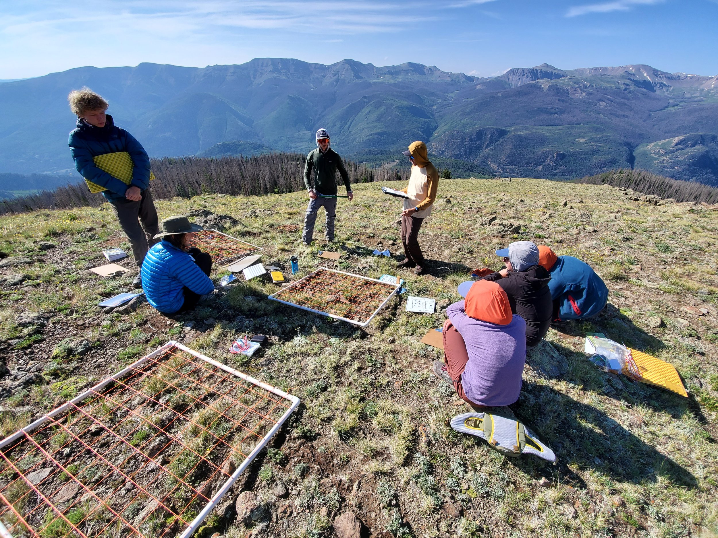
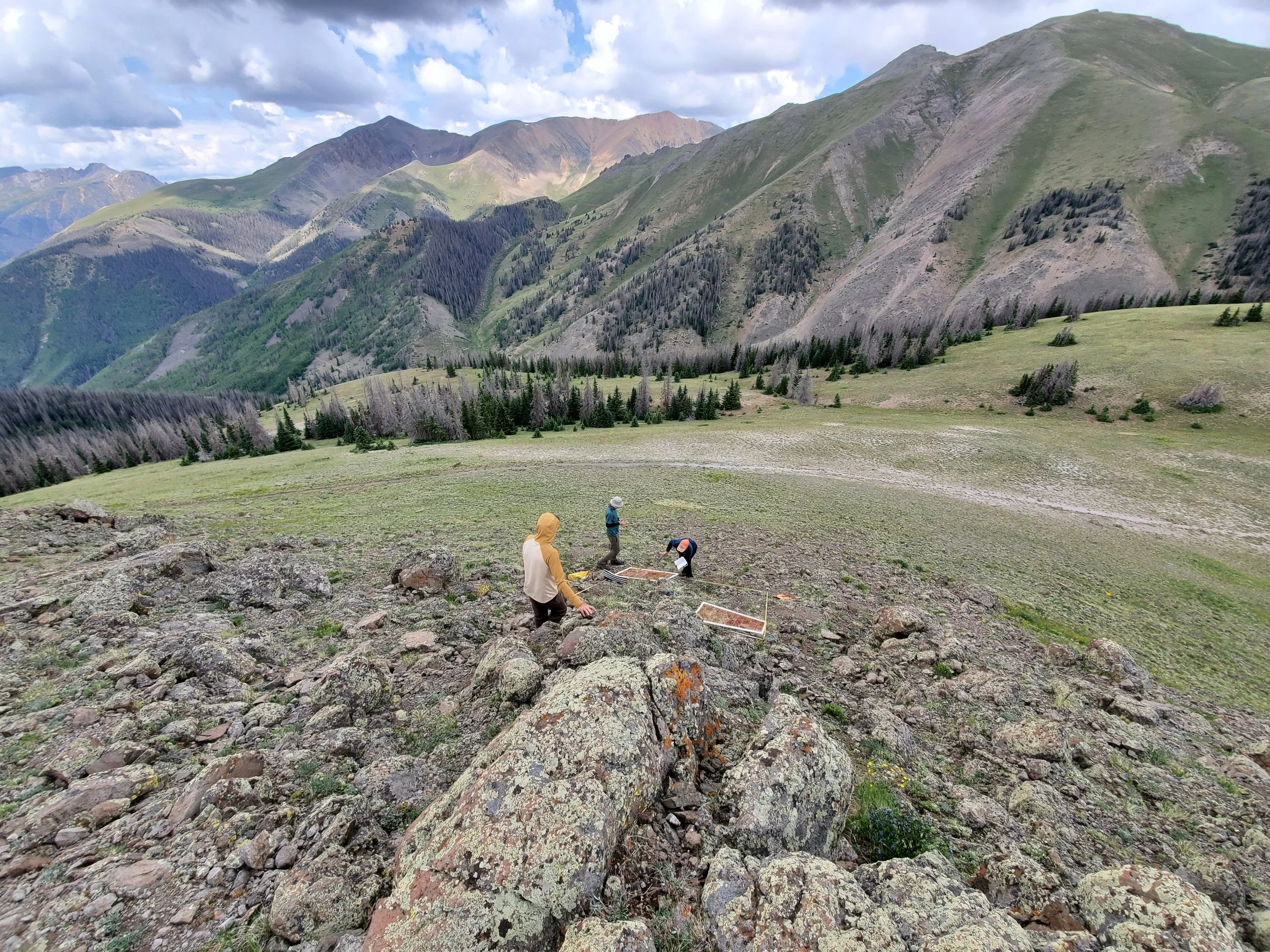
Monitoring plots were installed and surveyed from July 29 to August 9, 2006 on four mountain summits on BLM public land near Lake City, Colorado. The summit elevations range from 12,195 to 13,800 ft. Temperature dataloggers were dowloaded in summer 2008 and 2009. The plots are scheduled for monitoring every 5 years. The second monitoring phase was completed in 2011. MSI is partnering with Colorado Bureau of Land Management (BLM) to continue the program and the team completed monitoring in 2021.
An analysis of 2006 baseline data was completed by Dr. Julie Crawford for her dissertation with the University of Pavia, Italy. Manuscripts are currently being prepared and submitted for publication in scientific journals. MSI will build upon her analysis by adding in the 2011 and 2021 data sets.

MSI began planning the project more than a year prior to field work and several candidate locations were considered before picking the Lake City area. The project requires four summits along an elevation gradient beginning from just above treeline. The mountain tops have to be as conically-shaped as possible so that plots can be located on all four sides. Furthermore, geology and climate have to be very similar and peaks have to be as accessible as possible while avoiding areas impacted by recreation or mining.
The physical impacts associated with GLORIA projects are very minimal, by design. Each of the four summits is monitored using a specific observation protocol extending no farther than 10m below and 100m horizontal distance from a summit, with four main plots located at a specific distance below the summit in the primary cardinal directions. There are a total of 16 x 1 m2 temporary gridded quadrats (i.e., four in each plot). To facilitate repeat studies, small monument stakes (easily removed) or paint markers are installed to mark the summit origin point and the plot corners. The protocol also includes installation of a tiny, self-contained soil temperature monitoring sensor at a shallow depth inside each plot. The multi-summit array is observed at least once every five years with each summit requiring a team 2-3 full days to complete. Temperature sensors are downloaded every 2-3 years.
Principle Investigators:
Anthony Culpepper, Julia Ledford, Lenka Doskocil, MSI
Thanks to our collaborators who helped initiate the project:
Dr. Koren Nydick, who initiated the program during her tenure at MSI, currently with Rocky Mountain National Park
Peggy Lyons and Dr. Julie Crawford – Botanists, Colorado Natural Heritage Program and University of Pavia, Italy
MSI 2011 staff & interns: Chris Peltz, Kyle Skaggs, Lindsey Lennek, Beth Adams, Michael Freer, and Michael Costello
2006 Volunteers: Ellen Stein, Dr. Michael Kelrick & his “Wilderness Conservation Biology” class from Truman State University.
Thanks to the project funders:
2021 Resurvey, Analysis and Maintenance:
Colorado Bureau of Land Management (BLM)
2011 Funds for Survey:
Tres Rios Field Office of the BLM
2008-2009 funds for ongoing maintenance:
San Juan Public Lands: USFS & BLM
2006 Funds for project initiation and baseline survey:
San Juan Public Lands: USFS & BLM
Mountain Studies Institute
The Nature Conservancy of Colorado
American Alpine Club
Colorado Native Plant Society
Colorado Mountain Club
PikaNET: A Citizen Science Monitoring Program for the American Pika
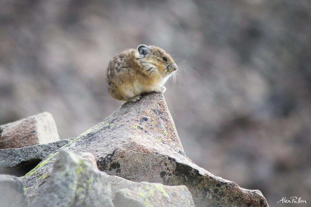
PikaNet is a citizen science initiative to engage people in monitoring the American Pika. This high alpine creature is considered an indicator species of climate change due to its high vulnerability to warming global temperatures. Annual trainings teach volunteers what species and indicators they are looking for, where to find them, how to collect data, and finally how to submit the data to a statewide online database. These workshops will be a combination of indoor and outdoor trainings.
Data that participants collect will become part of a larger effort to monitor pika populations in Colorado and across the Southern Rockies. The Denver Zoo will offer sister trainings in the Front Range of Northern Colorado.
CitSci.org serves as the portal for entering data and viewing the results of all submitted surveys. We expect to expand the geographic scope of the program in future years.
PikaNET is a collaborative effort between several organizations including the Mountain Studies Insititute, the Denver Zoo, Rocky Mountain Wild, Natural Resource Ecology Laboratory at CSU, and the San Juan Public Lands Center. The monitoring effort is linked to the research being done by Dr. Chris Ray and PhD. Candidate Liesl Peterson from the University of Colorado Boulder. Chris and Liesl have both been crucial to to the development of compatible protocols and procedures.
PikaNET: A Guide to Citizen Science Report:
A Model for Public Participation in Scientific Research in the San Juan Mountains 2010-2011 Final Report. Download this hands-on guide to learn more about PikaNET and citizen science, such as how to explore your own science question and organize your monitoring effort. MSI has published a detailed report on the process for planning your project.