New Tools for Evaluating Alpine Sensitivity & Water Quality in the Upper Animas Watershed in San Juan County, CO
The primary goal of this EPA-funded project is to take both existing and newly created data relating to water quality and to create an integrated user-friendly set of tools, i.e., maps, tables and GIS application, to be utilized by the San Juan County Board of County Commissioners (BOCC), Planning Commissioners and Assessor in making scientifically-based land use decisions—specifically as relates to effects on water quality and human health issues.
First Year Progress
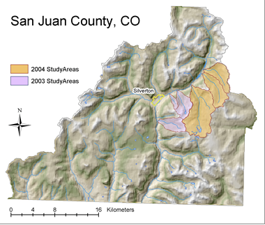
Good progress has been made to date on the first year work plan. In spite of a late start (Aug.1, 2003 related to funding delays), all field work in the first year study areas has been accomplished. Initial polygon maps of land types have been digitized along with water sampling and landmark point files. This data is currently being attributed, checked for accuracy and assembled into GIS. Approximately 20 square kilometers was mapped in Deer Park, Arrastra Gulch and Blair Gulch (twice as much as proposed). Ongoing analysis of water samples is being conducted at University of Colorado this fall. Now that the field season is over, existing water quality data gathered by the Animas River Stakeholders Group (1994-2001) will be arranged into a useful format for county planners.
Second Year Progress
Additional watersheds were mapped and water samples were analyzed. Animas River Stakeholder Group data was organized. All data was displayed spatially using Geographic Information System (GIS) mapping. An interactive web-based mapping tool was created for use by county planners. Results of the project were presented to the San Juan County Board of County Commissioners (BOCC), Planning Commissioners, and Assessor in the summer of 2005. MSI also trained the San Juan County planner on how to use the interactive web mapping tool and provided free tuition for the county planner and assessor to attend its Geothechnologies (GIS and GPS) course in October.
Collaborators
Dr. Mark Williams and Kim Raby (University of Colorado), Dr. Bill Simon (Animas River Stakeholders Group), and Bill Ball (Mountain studies Institute). MSI was awarded an EPA-Region 8 Regional Geographic Initiative grant to fund this project.